


Les Trois Becs

maupassant38
User
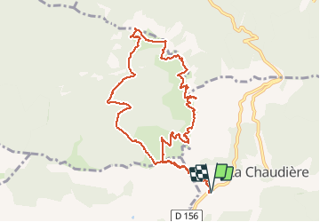

Length
11.9 km

Max alt
1565 m

Uphill gradient
942 m
Km-Effort
24 km

Min alt
1017 m

Downhill gradient
942 m
Boucle
Yes
Creation date :
2019-08-22 07:40:20.39
Updated on :
2019-08-22 12:18:48.692
4h02
Difficulty : Medium

FREE GPS app for hiking
 SityTrail
IGN / Geographical institutes
SityTrail Plus
The world is yours!
About
Trail Walking of 11.9 km to be discovered at Auvergne-Rhône-Alpes, Drôme, La Chaudière. This trail is proposed by maupassant38.
Positioning
Country:
France
Region :
Auvergne-Rhône-Alpes
Department/Province :
Drôme
Municipality :
La Chaudière
Location:
Unknown
Start:(Dec)
Start:(UTM)
674901 ; 4944135 (31T) N.
Comments